Dredging Plans
Sand and rock from the bottom of Coos Bay will be removed by dredging to make the Federal Navigation Channel 6 feet deeper and a 150 feet wider and develop turning basins for ships to maneuver. It is estimated that this will take about three years to complete. 13.93 million cubic yards of sand and 6.34 million cubic yards of rock will need to be removed, enough to fill the UO’s Autzen Stadium to the brim seven times.
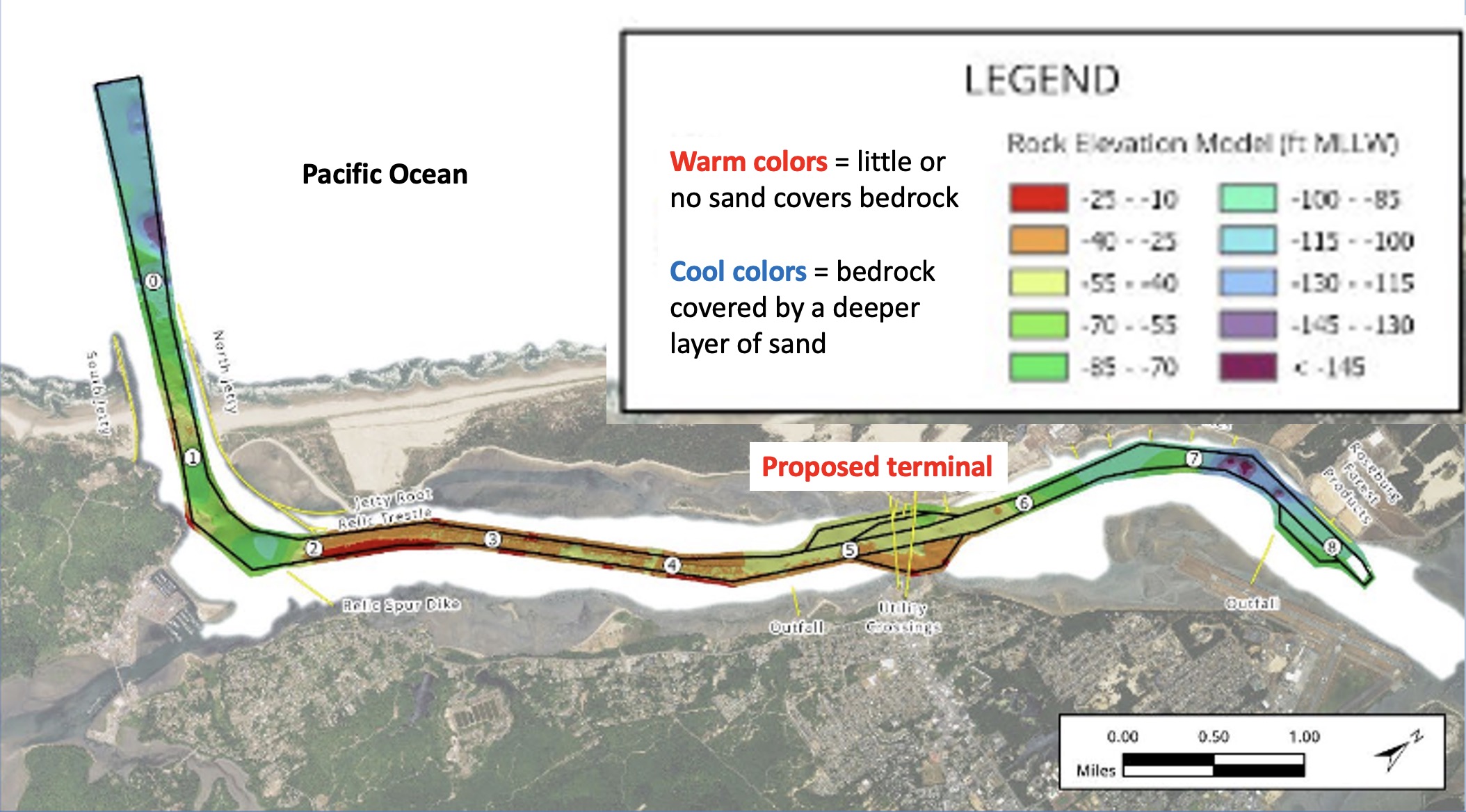
The permit request for this project to the USACE shows that 8.2 miles of the channel will be expanded, even though the shipping terminal would be located only 5 miles from the ocean. In addition to the channel expansion two turning basins are planned. One in front of the terminal so ships coming in can turn around to leave. The footprint of the this turning basin shows shows that it would stretch almost bank to bank from the North Spit to the community of Empire. Additionally the Coos Indian villages of Waikdee, Hanistitch, Intesitch, and Walitch were located along the shore here. The place across the bay from these villages, where the terminal would be located, is known as the Hollering Place. Travelers arriving on the North Spit shore would holler over to the villages for someone to paddle over and pick them up in their canoes.
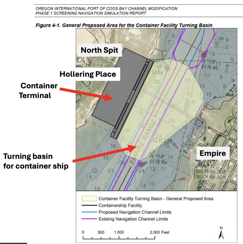
A second turning basin and a dredged channel is planned for three miles above the terminal for reasons that are unclear.

What happens when you remove all that sediment?
In the lower part of the bay bedrock has very little sand above it. Removal of the sand and the bedrock in these areas will turn the bottom of the estuary from a soft sediment environment that supports crabs and clams to a rock bottom environment that does not support these organisms.
In areas where there is still sand on the sides of the new channel that sand will continue to slump into the channel and need to be removed. In the seven years after the channel is initially dredged to the wider and deeper dimensions it is estimated than another 12 million cubic yards of sand will be dumped in the ocean disposal sites. This side slope equilibrium issue will mean the loss of shallow areas on the edges of the navigation channel that support eelgrass communities.
The second turning basin
It is unclear why there is a second turning basin, designed to accommodate capesize bulker ships at mile 8 which is next to the Roseburg wood chip terminal. The USACE permit request indicates that Roseburg has no need for a new turning basin and capsize bulker ships are too big to come into Coos Bay, even with a deeper and wider channel.
The role of the US Army Corps of Engineers (ACE)
The ACE is responsible for maintaining the federal navigation channels of the nation’s ports. To expand the Coos Bay channel the port needs to get a permit to determine whether it is in the Federal Government’s interest to assume the operation and maintenance of the navigation channel improvements that the port wants to build. The ACE has to determine if the channel expansion is economically justified and environmentally acceptable. The port is required to provide the ACE with considerable information to obtain this permit. The ports web site has all of the materials that they provided to the ACE in 2024 that have been made available for public review.
Where would they put the dredge spoils?
Dredge material (known as spoils) were historically placed in the bay creating islands, such as those off of the Ko-Kwel Casino Resort, or put onto salt marshes such as those in the Eastside area of Coos Bay. Now we dump dredged material in the ocean.
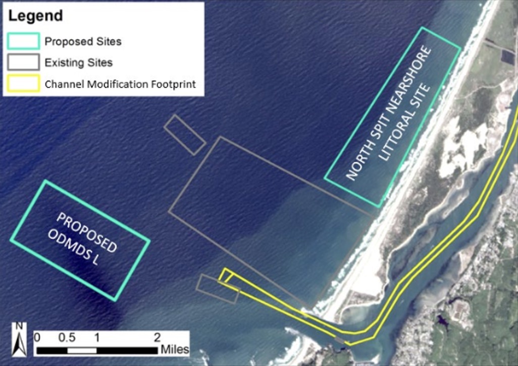
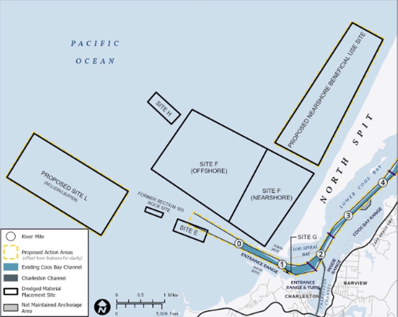
The existing dredged material disposal sites are not big enough for the large quantity of rock and sand that needs to be removed so two new sites are proposed.
A 2.3 square mile ocean area off of Sunset Beach would be the dumping area for both rock and sand. The second 1,000 acre site, close to the shoreline north of the jetty entrance, would only be used for sand disposal in calm weather as it is too close to shore for the dredge to safely access it in rougher weather.
| Phase | Task | Expected Operation Time Frame | Operational Duration |
|---|---|---|---|
| Channel / Turning Basin | |||
| 1A | Dredge Sand | 6/15/2027 - 12/17/2027 | 26 weeks |
| Cutter - Dredge Rock | 8/22/2027 - 11/6/2027 | 11 weeks | |
| Mech - Dredge Rock | 6/15/2027 - 12/2/2027 | 24 weeks | |
| Cutter - Pre-Treat Rock | 6/17/2027 - 12/8/2027 | 14 weeks | |
| Mech - Dig Pre-Treated | 6/26/2027 - 11/18/2027 | 21 weeks | |
| 2 | Dredge Sand | 6/15/2028 - 1/11/2029 | 30 weeks |
| Cutter - Dredge Rock | 6/24/2028 - 10/31/2028 | 18 weeks | |
| Mech - Dredge Rock | 6/15/2028 - 12/2/2028 | 24 weeks | |
| Cutter - Pre-Treat Rock | 6/15/2028 - 12/1/2028 | 6 weeks | |
| Mech - Dig Pre-Treated | 6/24/2028 - 10/26/2028 | 18 weeks | |
| 3 | Dredge Sand | 6/15/2029 - 10/19/2029 | 18 weeks |
| Cutter - Dredge Rock | 6/15/2029 - 10/17/2029 | 17 weeks | |
| Mech - Dredge Rock | 6/15/2029 - 12/2/2029 | 24 weeks | |
| Cutter - Pre-Treat Rock | None | - | |
| Mech - Dig Pre-Treated | 6/15/2029 - 9/21/2029 | 14 weeks | |
| Terminal Dredging | |||
| 1B | Dredge Sand (Mech) | 6/15/2027 - 1/11/2028 | 30 weeks |
| 2B | Dredge Sand (Mech) | 7/19/2028 - 9/17/2028 | 9 weeks |
| Dredge Sand (Hopper) | 6/15/2028 - 8/29/2028 | 11 weeks | |
| Dredge Rock (Mech) | 9/18/2028 - 12/29/2028 | 15 weeks | |